
The following post is adapted from a talk I gave recently at the Catalyst Club in Brighton about hand drawn and hand made maps and some of the stories behind them. To describe the Catalyst Club eloquently is difficult but this quote, taken from the website is perfect –
‘Established in 2004, The Catalyst Club is a unique monthly Brighton event that pays tribute to the old traditions of French Salon, debating societies and Gentleman’s Clubs. Since its inception the Catalyst has hosted over 500 talks that have included zombie films, Marmite, the history of the Martini, the suffragettes, Spartans, demonology, bum reading and slime mould. On the night three guest speakers take to the lectern to talk for fifteen minutes on a subject close to their heart. The Catalyst Club is open to anyone with a passion, no matter how bizarre or niche.’
Much of the talk came from research edited out from my book ‘Hand Drawn Maps’ because of lack of room. But it was information I found interesting and perhaps somewhere, there is another book about maps and the mapmakers themselves that I’ll write some day…
My interest in maps comes from an ill fated job just after university in a shop selling antique prints. I was a disaster and got the sack after three weeks but I did take away a fascination for the crudely coloured charts of the 17th century. Each was hand drawn, engraved and printed and the personality of the map maker shone through in every line and comment. As digital maps, inherently ‘personality free’ and ubiquitous, are becoming the way we understand our environment, I became interested in other ways people have mapped their worlds. In particular, I was interested in maps made by hand – where the soul of the mapmaker can still be felt and something of their stories still exists. This post is not a comprehensive history of hand made mapping, or a look at the most important mapmakers of their time. Rather, it’s a look at particular techniques that interest me and some stories that caught my attention.
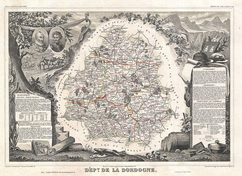
Shall we visit Dordogne?!
Let’s start at the beginning though with perhaps one of the oldest maps and map makers in the world.
Imagine a stone age person living somewhere in, what we now know as, Dordogne in France 17,000 years ago. He’s living with a small group of people hunting and gathering to survive. He has the same level of intelligence as we do but has less tools and knowledge to manage his world. In an effort to control life, his society is beginning to develop beliefs in supernatural powers and use religious rituals that they believe will help them.
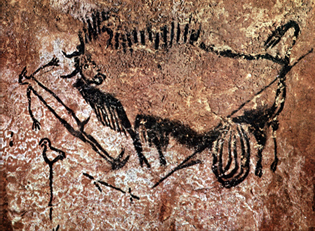
Lascaux star map
This is the map he produces. Believe it or not, this is a map of the sky. It uses pictograms, ie: the features are represented with pictures alone, drawn using natural minerals on the wall in the Lascaux cave complex.
Research suggests that the eyes of the bull, the strange sleeping birdman and the bird-on-a-stick correspond to three prominent stars known as the Summer triangle. They can be picked out easily as the brightest objects in the sky at the height of the Paleolithic Summer. Research in further caves suggests more maps of the constellation of Taurus. We will never know what the purpose of these maps were for. Perhaps they are simple documentations of an environment and a way to share knowledge with others. Perhaps they are part of a religious ritual. They are of places that the maker never visited but I imagine, viewed as important in some way for the group’s survival.
Let’s go to Greenland!
Our next mapmaker lived in the far North and represented his world sculpturally, making maps created as 3d objects rather than on a flat plain.
His name was Kunit and he came from 19th century Greenland from a small community called Umivik consisting of 19 people. There are few resources other than meat and its byproducts. There are few trees and any wood comes by way of the sea. His way of life hasn’t changed for centuries and neither has the kind of maps he makes. Perhaps similar maps were used in the Stone Age too.
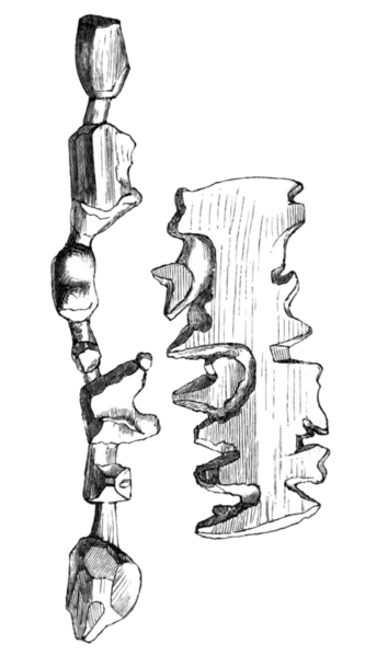
Ammassalik maps from Greenland
This is the kind of map Kunit made, brought back to mainland Europe by the explorer Gustav Helm in 1885. Perhaps it was traded, perhaps it was used to reach out to the strange Danish foreigner. It’s carved in driftwood and shows the coastline and fishing points in a continuous line up one side and then the other. It’s fist sized and fits into a mitten or a cagoule pocket easily. It’s lightweight, waterproof and it also floats – perfect for fishing trips. It can be shared with others as knowledge and as a way to form bonds . Perhaps this is also evidence of a map that can be felt as a tactile object. It’s a different way of understanding a location, of feeling it when visibility is very poor – when there’s a white-out or a sea fog and you can’t see your hands in front of your face.
Trip to The Marshall Islands?!
Our next mapmaker comes from the South, the Marshall Islands in the Pacific. He also made sculptural maps. He too relies on the sea for food. His home was settled three thousand years ago and his ancestors had to make frequent journeys between more than 1,100 islands spread out over 29 coral atolls. He too has few material resources but manages to sail 1000s of miles without any sophisticated technology.
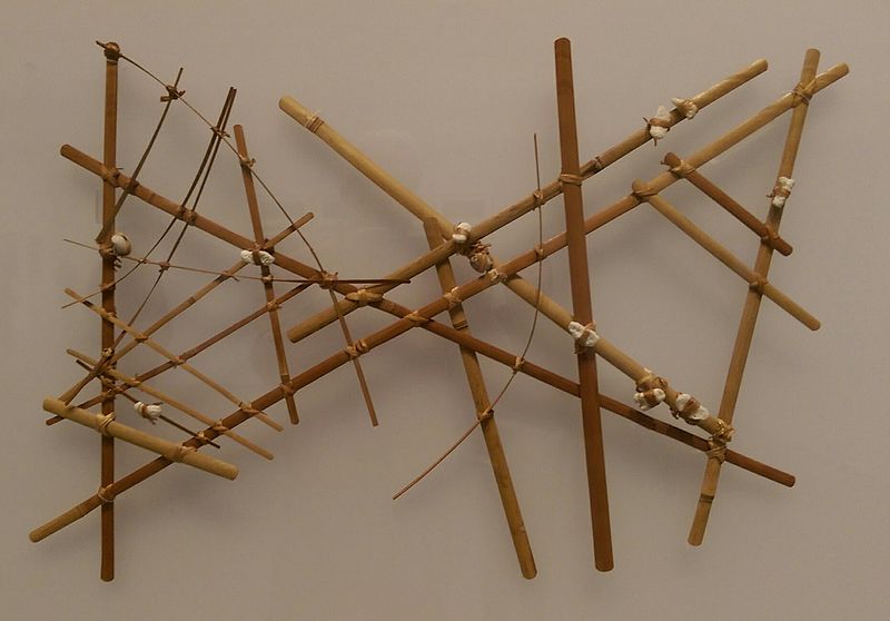
Marshall Island stick map Photo by Jim Heaphy
Author Cullen328
This is the kind of map he made – a stick map. It’s a maritime chart made from coconut fibres and shells. The curved sticks show swells. The short, straight strips show currents and the small cowry shells represent the islands themselves.
The mapmaker won’t take it with him on his journeys but will memorise it. He may be the only person to understand what it means. This kind of map is for personal documentation only, so actually very different from the other maps we’ve looked at. It was a closely guarded secret that only a select few rulers knew, and the knowledge was passed on from father to son. When making journeys, multiple canoes would sail together in a flotilla, accompanied by a leader skilled in use of the charts. These maps didn’t share knowledge, they used knowledge as power and status.
So you can see from these three examples how people started to document their environment: the skies, the coastline and the sea itself. Each map is radically different to each other. They are made using the resources available to the mapmaker and have multiple purposes – for documentation, survival, to make bonds and maintain power. Next time, I’ll continue the post with examples of early road maps and the birth of the Ordnance Survey with esoteric stories of shipwrecks, rebellions, invasions and plum pudding parties…..
Such a great post. Thank you. Very illuminating.
Thanks Paul. Maps really are great!
So interesting. Thank you. I create maps for genealogy clients.
Thanks Ann! Do you have any maps on your website? I’ll check them out!